In this story · 3 sections
The Colline du Château is the great limestone rock that rises between the old town of Nice and its harbour. For the people of Nice, "the château" means a park and a place to walk rather than a fortress, and its panoramas change as you circle it: the port at sunrise, the Baie des Anges and the Promenade des Anglais at sunset.
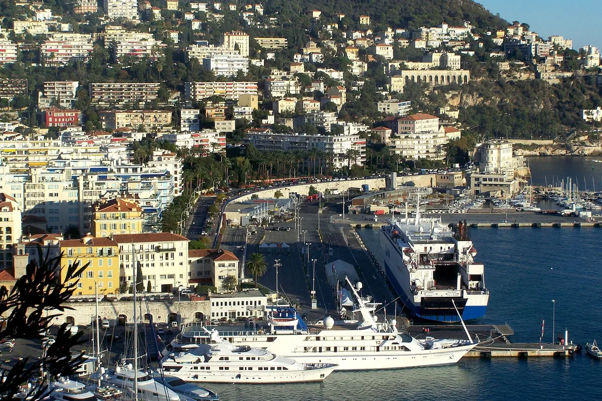
Climb it in the morning, come down on the eastern side and you arrive at Port Lympia, the harbour where ferries leave for Corsica and fishing boats share the quays with yachts.
4 places
© OpenStreetMap contributors · OpenFreeMap
- 01Cascade du Châteausee · Colline du Château
- 02Tour Bellandasee · Vieux Nice
- 03Église Notre-Dame-du-Portsee · Le Port
- 04Phare de Nicesee · Le Port
- 1388
- Nice passes to Savoy; the hill becomes a stronghold
- 1543
- Franco-Ottoman siege
- 1706
- Fortress razed on Louis XIV's orders
- 1750
- First caisson of Port Lympia's outer mole sunk
- 1885
- Waterfall built on the ruins of the keep
The fortress they called impregnable
A wall near the hill is first recorded on 20 January 1002, and from the 11th to the 18th century the rock carried a fortress that grew with every war. After Nice gave itself to Savoy in 1388 the hill became a strategic stronghold, guarding the sea approach and the border between Italy and France. Cannon ports were cut into the keep in 1506, and a very deep well, dug with enormous effort, was hailed as the "eighth wonder of the world". Sixteenth-century writers called the place impregnable.
It was besieged in 1543 by the troops of François I and Suleiman the Magnificent, taken in 1691 by Louis XIV's army under Catinat, and besieged again from 1705. Between 11 November 1705 and 4 January 1706 the French batteries fired more than 14,000 bombs and 39,000 cannonballs. On 2 January 1706 Louis XIV ordered the remaining fortifications to be levelled with explosives.
From ruin to park
Work on turning the hill into a public park began in the 19th century, though cows and goats still grazed there in 1831. In 1885 the decorative waterfall planned since 1826 was finally built on the ruins of the keep; it also served as the overflow for Nice's first water supply. Military restrictions on building in the park were lifted in 1924. In 1943–44 the German army fortified the hill again, demolishing low houses and cutting barracks and tunnels into the rock.
A few traces of the fortress survive: great fallen blocks near the excavated old cathedral, and, by the belvedere above the waterfall, the base of the keep's north wall, still marked by the impact of a cannonball. At the foot of the hill, by the Place Garibaldi, excavations uncovered the medieval Pairolière tower and bastions razed in 1706, now protected in an archaeological crypt.
Port Lympia
The harbour takes its name from the Lympia spring, which fed a small lake in a marshy valley at the foot of the old citadel. In 1748 King Charles-Emmanuel III decided to build a port there, and on 22 July 1750 the first caisson of the outer mole was sunk. The work took more than a century and a half. The plan approved in 1840 by Nice's Consiglio d'Ornato, drawn by the city architect Scoffier, gave the harbour its symmetrical, theatrical layout.
Today the 20-hectare port has more than 500 berths, with the commercial harbour at the entrance and the marina at the far end. As the closest point of mainland France to Corsica, it is the departure point for ferries to the island. At the head of the harbour, the neoclassical church of Notre-Dame-du-Port, the arcaded façades of the square and the monumental Truchi staircase on the Quai Cassini have been listed since 1991. At the end of the breakwater stands the lighthouse of Nice.
Cascade du Château
The 1885 waterfall on the ruins of the keep
Built on the remains of the keep, with the belvedere above.
Terrasse Nietzsche, 06300 Nice
Insider tipLook for the cannonball mark on the keep's north wall nearby.
Tour Bellanda
Tower on the seaward side of the hill
A landmark above the eastern end of the Promenade.
Tour Bellanda, 06300 Nice
Insider tipA good starting point for the climb.
Église Notre-Dame-du-Port
The neoclassical church at the head of the port
Listed in 1991 with the arcaded façades around the square.
Place de l'Île-de-Beauté, 06300 Nice
Insider tipBest seen from across the water.
Phare de Nice
The lighthouse on the breakwater
At the end of the harbour wall, facing the Baie des Anges.
Digue du port, 06300 Nice
Insider tipWalk out for the view back to the hill.
Neighbourhood and property data for Nice is on VERA PI, and more from the city is on metromode.co and metromode.se.