A silver-route town in the Bajío that lit the fuse of Mexican independence, nearly became a ghost town and was saved by artists. San Miguel de Allende in two days, from the Jardín to the painted sanctuary of Atotonilco.
In this story · 5 sections
San Miguel de Allende is a town in the far east of the state of Guanajuato, in the Bajío region of central Mexico. It takes its name from a sixteenth-century friar, Juan de San Miguel, and from Ignacio Allende, a hero of Mexican independence born in a house facing the main square. Its historic centre – a core of 43 hectares filled with buildings from the seventeenth and eighteenth centuries – is part of a World Heritage Site, and every year it draws thousands of visitors and new residents from abroad.
01Frontier, fortune and independence
Before the Spanish, this was a Chichimeca village called Itzcuinapan, and during the Chichimeca War of 1540–90 the area was a frontline of resistance to Spanish colonisation. The town was refounded in 1555 as a mission and military outpost beside two freshwater springs, which supplied all its water until the 1970s. By the mid-eighteenth century it was one of the most prosperous settlements in New Spain, with some 30,000 inhabitants – more than Boston or New York at the time – and most of its mansions, palaces and churches date from that golden age.
In September 1810, after Miguel Hidalgo's Grito de Dolores just to the north, the insurgent army marched into San Miguel, stopping first at the sanctuary of Atotonilco, where Hidalgo took a banner of the Virgin of Guadalupe. San Miguel became the first Mexican town to win its independence from Spain.
02The Jardín and the Parroquia
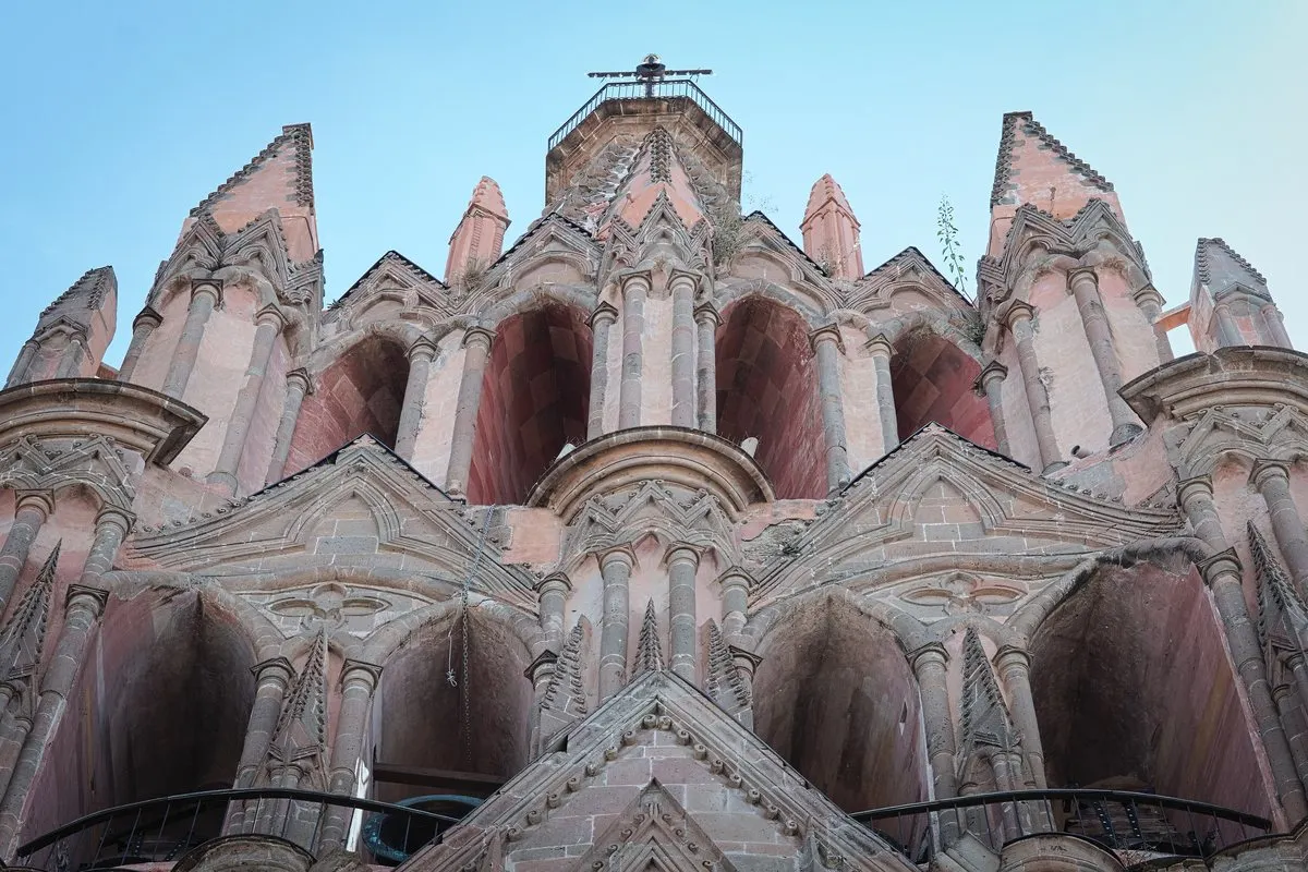
Start in the Jardín Allende, the main plaza, with its formal planting, wrought-iron benches and Indian laurel trees; bands often play in the kiosk at weekends. Overlooking it stand the Ignacio Allende House, the Canal House and the municipal palace – and the Parroquia de San Miguel Arcángel, whose pink towers can be seen from most of the town.
The church itself dates from 1680–85 and originally had a traditional Mexican facade. Its present neo-Gothic front was built in 1880 by Zeferino Gutiérrez, an Indigenous bricklayer and self-taught architect. He is said to have worked from postcards and lithographs of European Gothic churches, but the result is his own – more an act of imagination than a copy. Beside it stands the Santa Escuela church, founded in 1742.
03Doors, courtyards and the artists
The historic centre has an estimated two thousand doors and at least as many courtyards behind them, many restored with facades of ochre, orange and yellow and frames of hand-forged iron and hewn wood. Wander without a plan, and step into the Centro Cultural Ignacio Ramírez, known as Bellas Artes, in the former Concepción convent founded in 1775.
Those courtyards nearly emptied. Early in the twentieth century, after an influenza pandemic, San Miguel came close to becoming a ghost town. Foreign artists rediscovered it and founded art schools – the Escuela de Bellas Artes in 1938 and the Instituto Allende – and the muralist David Alfaro Siqueiros came to teach. After the Second World War American veterans arrived to study on the G.I. Bill, and the town has drawn foreign residents ever since.
04Atotonilco: the Sistine Chapel of Mexico
On the second day, drive 14 kilometres north to the Sanctuary of Jesús Nazareno de Atotonilco, the other half of the World Heritage Site. Founded in the eighteenth century by Father Luis Felipe Neri de Alfaro, it looks like a fortress from outside, with plain walls ten metres high. Inside, almost every surface of the nave and chapels is covered with Mexican folk-Baroque murals, mostly painted by Antonio Martínez de Pocasangre over some thirty years – which is why it is called the Sistine Chapel of Mexico. It remains a place of worship and penance, receiving as many as 5,000 visitors a week. Thermal springs rise nearby.
05Planning
San Miguel is 86 kilometres from Querétaro; the centre is steep and cobbled, so bring good shoes. For more, see our destinations, the Metro Mode camera for reading buildings as you walk, and the Metro Mode home page.